The Dolomites (or Dolomiti in Italian) hold a special place in my heart. This vast mountainous region of northern Italy has been my go-to place to satisfy my nature craving. Truly, there is no other place in Western Europe like it. The Dolomites, despite being located next to the Alps, are uniquely different and are well-known for their rocky and limestone formations and mind-blowing jagged mountains. There are hundreds of well-marked hiking trails, climbing routes, and via Feratta’s around the area. It is really a perfect place for nature lovers and I always want to explore the non-touristy parts of the Dolomites.
In late August 2020, my husband and I decided to hike one of the most popular long-distance trekking trails in the Dolomites, called Alta Via 1 (which literally means High Route 1). Our initial plan was to do the Tour du Mont Blanc trail in the Alps. However, due to COVID-19 and the uncertainties in terms of crossing through 3 different countries, we decided to take a safer option and Alta Via 1 seemed to be the better option than Tour du Mont Blanc at this point.
The Alta Via 1 trail is perhaps the easiest in the Dolomites, starting from Lago di Braies in the north to Belluno in the south. It usually takes between 6 and 11 days to complete this route and we did it in 10 days (which includes 1 rest day due to bad weather). I have written a stage-by-stage itinerary of the full Alta Via 1 hike below. Some of the stages can be combined depending on your physical abilities and how many things you carry. Since we carry camping equipment, 10 days were quite reasonable.
Please note that wild camping in the Dolomites is officially prohibited, so we followed strict rules of leaving no trace, camping out of sight, pitching a tent before the sunset, and packing just after sunrise.
- Map & Vlog
- Stage 1: Lago di Braies to Rifugio Biella
- Stage 2: Rifugio Biella to Rifugio Fanes
- Stage 3: Rifugio Fanes to Mt Lagazuoi
- Stage 4: Rifugio Lagazuoi to Rifugio Nuvolau
- Stage 5: Rifugio Nuvolau to Passo Staulanza
- Stage 6: Passo Staulanza to Rifugio Vazzoler
- Stage 7: Rifugio Vazzoler to Rifugio Bruto Carestiato
- Stage 8: Rifugio Bruto Carestiato to Rifugio Pramperet
- Stage 9: Rifugio Pramperet to La Pissa
Map & Vlog
Stage 1: Lago di Braies to Rifugio Biella
- Distance: 6.9 km (~ 4-5 hours)
- Elevation Gain / Loss: 929 m / 96 m
- Where to snack/have lunch:
- None
- Where to stay:
- Rifugio Biella
- Rifugio Sennes (+3.1 km from Rifugio Biella)
September is an off-peak season as we prefer to hike with fewer people. Of course, the drawback is that the weather may get quite bad as it’s almost autumn. And it DID get relentless with thunderstorms and heavy rains. We had the option to stay in the town for another night but we preferred to stay in the mountains instead so, as the Brits said, we just winged it! We started our journey by bus from the ski town of Cortina d’Ampezzo, where we stayed the night before, to the small town of Dobbiaco (or Toblach in German). From here, we took another bus to the starting point of our hike at the beautiful and picturesque Lago di Braies, which was unfortunately covered in thick white fog. Yep, we could not see the iconic turquoise blue of the lake at all! How disappointing!


We waited for half an hour for the rain to stop near the famous Hotel Lago di Braies, before deciding to start walking as soon as we saw a window of opportunity. Unfortunately, the rain picked up again before our first ascent. No Gortex rain jackets could completely protect us from this relentless rain and we were lucky to have bought a pair of cheap ponchos at a souvenir shop near the hotel. Even though our trousers were slightly wet, we managed to keep our upper body, backpacks, and everything inside them dry, thanks to the yellow ponchos that made everyone who passed us smile, since we looked like a giant Pikachu. 🙂


But alhamdulillah, the sky cleared up before we reached the first “via Ferrata” (short one thankfully). By Italian standards, this was not called a via Ferrata, but I called it this way, due to the fact that we had to hold metal cables as we climbed a vertical hill. That short and thrilling climb was worth it, as we were offered a magnificent view of the lake and the rocky mountains around it. It was truly amazing! By the time we passed the valley and arrived at the first mountain hut, Rifugio Biella at 2,327-meter elevation, we decided to call it a day. It was raining heavily again on the other side of the mountain where the rifugio was located, and we’ve been hiking for 5 hours. We had not acclimatised to the Italian mountains yet and we certainly did not used to carrying such huge backpacks. Even though this was considered the shortest and probably the easiest hike out of all of the Alta Via 1 path, we just could not say no to the thought of warm showers and warm beds. Wild camping and the idea of trying to find a decent place to wild camp in this weather were absurd. We were just too tired.
We were very lucky that there was one empty room of at least 4 beds at the rifugio. It looked like some people cancelled as the weather took its course. The rifugio was very basic; there was no hot shower, but at least we could dry our clothes. The food was pretty decent, nothing to shout about.
Stage 2: Rifugio Biella to Rifugio Fanes
- Distance: 13.1 km (~ 5-6 hours)
- Elevation Gain / Loss: 613 m / 880 m
- Where to snack/have lunch:
- Rifugio Pederü (great food!)
- Where to stay:
- Ücia dles Muntagnoles
- Rifugio Fanes (very comfy rifugio!)
- Ütia de Gran Fanes (+2.5 km from Rifugio Fanes)
Compared to the first day, the second day of the Alta Via hike was a breeze. It was like hiking a British mountain. There was a long walk and gradual descent from Rifugio Biella, where we stayed for the night. Some parts of the tracks are World War 1 military roads so the paths were quite wide and they are currently used to supply the rifugios. Unfortunately, the sun was nowhere to be seen and the clouds covered most of the mountains. Otherwise, the mountain backdrop could have been beautiful. The trail continued as it sharply descended from mountain pastures to forests surrounded by rugged limestone peaks. These unique limestone peaks are the main features of the Dolomites and we’re starting to see more of that now. We sharply descended to below treeline towards Rifugio Pederü, which was a perfect place to have lunch before we tackled yet another climb and ascend.


The food at Rifugio Pederü was amazing (Italian food never disappoint!) and we saw a lot of people here as the rifugio can be accessed by car. By this time, we had descended more than 800 meters, below the tree line and we had to start climbing again above the tree line at 2,096 meters (~ 600 meters ascent). The path across the valley was not interesting at all, but it got better as we reached the Fanes forests. We arrived past lunchtime at Rifugio Fanes, so we ordered simple panini (sandwiches) for lunch. From the rifugio, we ascended all the way to another green pasture, passing through beautiful lakes along the way.


We kept going, walking passing the last rifugio on this trail (Utia de Gran Fanes), and decided to wild camp in one of the forests surrounded by mountains just before the sunset. Our strategy for today was basically to walk as far as we could (~16 km) so that the next day was slightly more bearable. We somehow had the expectation of not-so-bad weather tonight. Regrettably, it rained the whole night and our “perfect” campsite became a pool of water. We had to quickly find higher ground and move the tent in the middle of heavy rain before the inner part of the tent submerged into water. It was an evening full of adrenaline! Two lessons we learned so far while wild camping: do not camp when the wind is above 20 miles per hour and always find a ground that won’t collect rainwater.
Stage 3: Rifugio Fanes to Mt Lagazuoi
- Distance: 12.7 km (~ 6-7.5 hours)
- Elevation Gain / Loss: 1,069 m / 377 m
- Where to snack/have lunch:
- Rifugio Lagazuoi
- Where to stay:
- Rifugio Lagazuoi
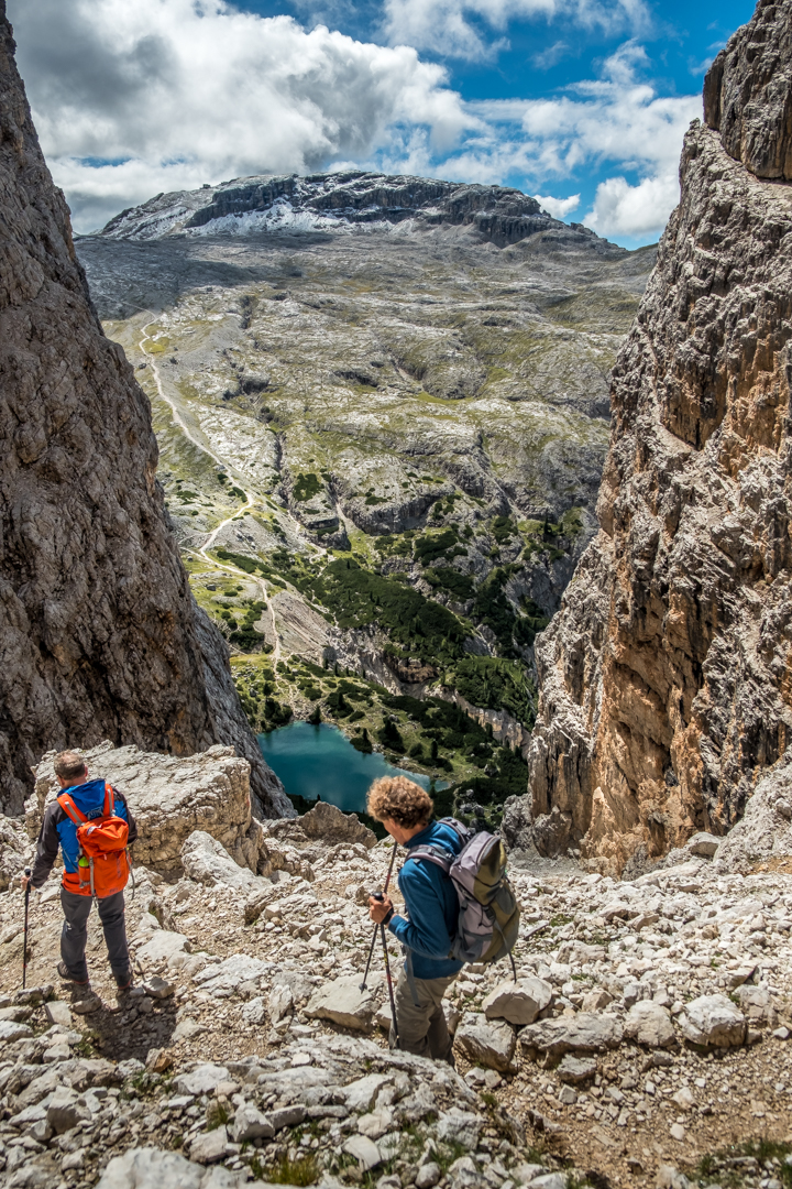
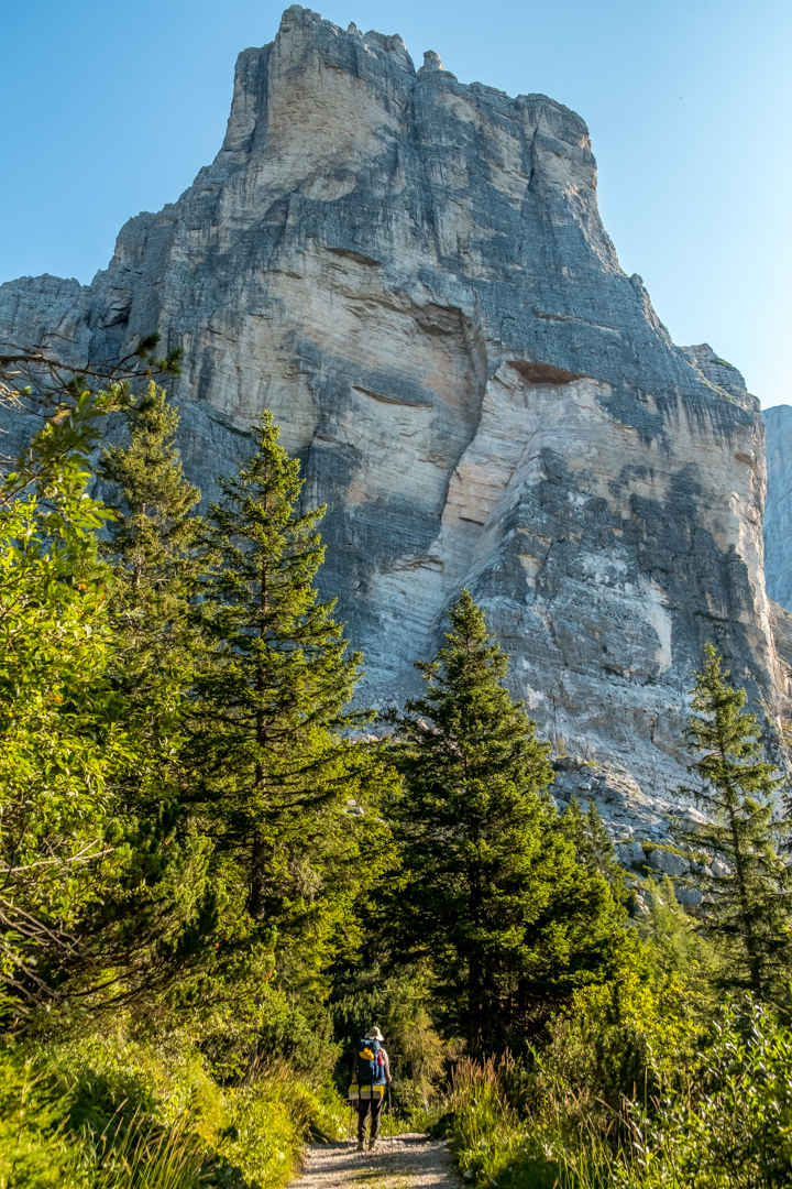
The third day of the hike was one of the hardest and longest trails of Alta Via 1. Even though we hiked further and covered more kilometres than expected on the previous day, the hike remained the most challenging one we did on Alta Via 1 so far. The hike started pretty easy through green pastures and tarns. But then the terrain got harder and steeper as soon as we started our long climb to a high rocky pass, Forcella dl Lech (2,486 meters). There were certain places where I had to crawl or hold rocky walls with my hands as the paths were too narrow, which made me quite doubtful whether it was a good idea to go through this path. Unfortunately, the alternative path was quite a detour and I just had to persevere. Little did we realise that passing through narrow gorges and ravines was indeed a feature of Dolomiti. For the next few days, we would be walking through these narrow paths all the time. We just had to be extra careful with our footings and balance.


The view was already spectacular with different shapes of rocky mountains halfway through Forcella dl Lech. From the top of the pass, we could already see Rifugio Lagazuoi, perched on top of the famous Mt Lagazuoi. It was daunting and demotivating to know that we had to do one of the scariest and steepest descents from Forcella dl Lech to Legacio Lake and climb up again for 700 meters to reach one of the highest rifugios (mountain huts) in the Dolomites. With a heavy backpack, it surely wasn’t easy! The hike to/from Lagazuoi was quite interesting as we passed through remnants from the First World War: trenches, tunnels, ruined barracks and even rusted debris were all over the place. The mountain and its surroundings were the locations of fierce fighting between Italian and Austro-Hungarian troops, which resulted in Italy gaining control of the Dolomites. That’s the reason why Lagazuoi and its surroundings are known for its open-air war museum!
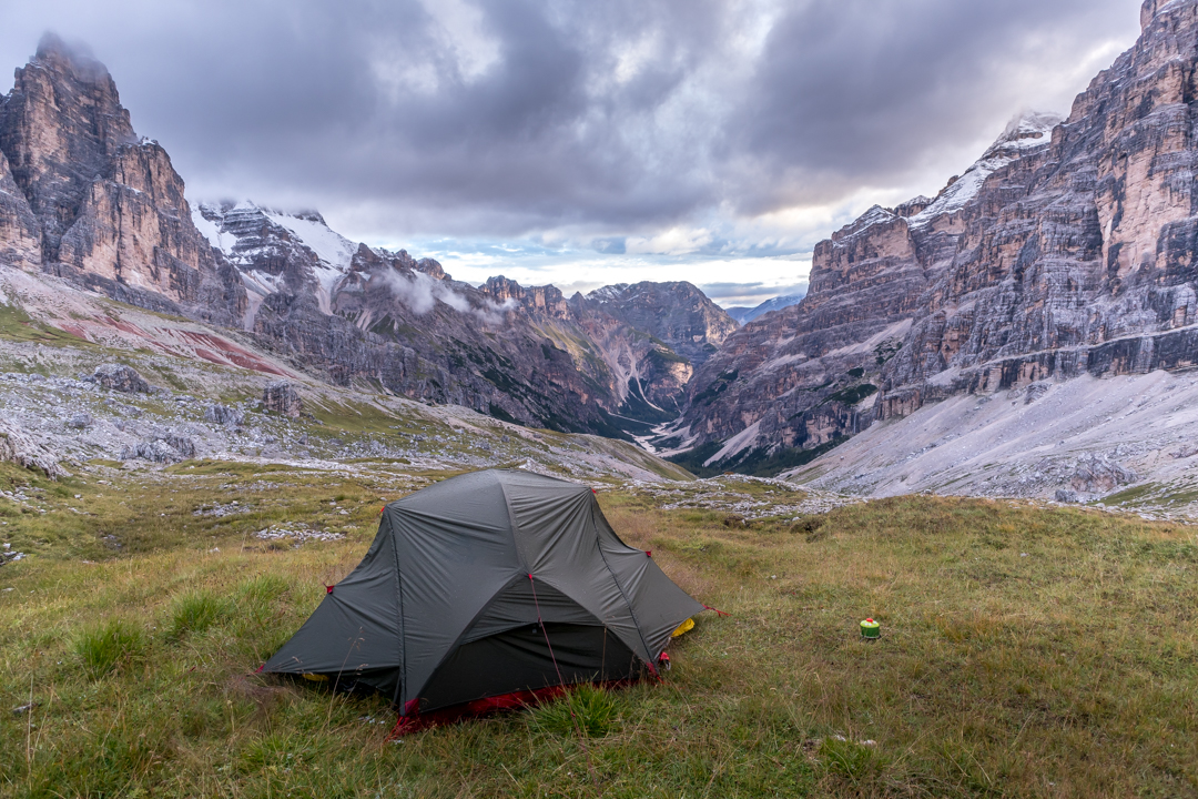
As soon as we reached the rifugio, we were spoilt with one of the best 360-degree views of the mountainous Dolomites. It was TRULY breathtaking! Mountains in a variety of unique shapes fiercely stood as far as your eyes could see. Unfortunately, we couldn’t stay in the rifugio as it was sadly fully booked. The rifugio was packed with people, some of them hiked all the way up from different points and some took a cable car up. Since there were no hopes of anyone cancelling their stay here at the rifugio, we decided to slowly descend the mountain towards Travenanzes Valley and pitched a tent with the view of the southern face of Il Castelletto and Tofana di Rozes (two of the famous mountains in the Dolomites). I was so glad that we were able to complete this portion of this tough hike and we thought the hike got easier after this. Well, we were definitely mistaken!


Stage 4: Rifugio Lagazuoi to Rifugio Nuvolau
- Distance: 13.4 km (~ 6-7.5 hours)
- Elevation Gain / Loss: 944 m / 1,121 m
- Where to snack/have lunch:
- Rifugio Dibona
- Rifugio Cinque Torri
- Where to stay:
- Rifugio Scoiattoli
- Rifugio Averau (great views + best food in the entire AV1)
- Rifugio Nuvolau (best views)
The fourth day of Alta Via 1 was not that difficult compared to the previous day. Perhaps because we were getting used to hiking a steep Alpine mountain and carrying such a heavy backpack on our back. Since we had been camping for two nights straight (and the fact that the first mountain hut we stayed in did not have a hot shower), it was a good time to stay in the rifugio again to freshen up. Unlike the previous experience, we booked Rifugio Averau due to its extremely high rating, especially in terms of food (food is the trigger word for any Asians!). It proved to be our best decision yet!
There are plenty of ways to pass this stage to Mt Averau. One can take the cable car route to descend from Rifugio Lagazuoi and/or other sections of the mountain. Another way and perhaps the most interesting one is using the World War I tunnels, which were built by the Italians to attack Austrian positions on the other side of the valley. The tunnels seemed to be an intriguing option, but we were not sure whether bringing a huge backpack would affect the whole experience. We eventually decided to follow the notorious and challenging 402 route as we wanted to enjoy the view of the valley and the mountains, including Cinque Torri (5 Towers). It may not be the safest route due to its yet another narrow rocky footpath as it traversed underneath Tofana di Rozes. Notice a familiar pattern here?
Unfortunately, the weather was not at its best. It rained for the whole day and the mountains were covered by clouds most of the time. Interestingly, as we descended towards the valley, the landscape changed into a thick muddy forest, which reminded me of the forests in Cameron Highlands, Malaysia. After more than 500 m of descent, we crossed an asphalt road and ascended again through the forest to above the tree line, passing through Cinque Torri (almost 700 m of ascent), where we stopped for a heartful lunch at Rifugio Cinque Torri. It felt quite surreal to be on the other side of the mountain — as the rain cleared and the sky turned blue again, we could finally see the majestic Tofana di Rozes (and other Tofana mountains). Simply breathtaking!


The hike from Cinque Torri to Mt Averau was quite straightforward and quick, and before we knew it, we arrived at Rifugio Averau. My first impression of the rifugio: it’s like a hotel! Although we stayed in a dorm sharing with 2 Italian oldies, it was clean and had a lot of facilities that we needed: washing & drying machines (badly need this as we only had 1 spare of hiking clothes and 1 for sleeping), hot shower, and a toilet with a bidet! That’s what I love about travelling around Italy. Most well-equipped hotels or accommodations have bidets in their toilets! What a great revelation!
As with all rifugios, the dinner service is between 7 pm to 8 pm. The cost of the rifugio usually includes dinner and breakfast. Dinner would consist of two main courses and a dessert. I was surprised that a whole plate of pasta dishes is considered a first course! The second course would usually involve meat or fish. Since some parts of the Dolomites are German-speaking, the rifugio not only serves Italian foods but also Austrian foods. Unlike the rifugios in the Tour du Mont Blanc trails, Italian rifugios always have good vegetarian options. At Averau, I decided to order spaghetti using dried fish eggs (a recipe from Sardinia) and it was LIFE CHANGING. It was simply the BEST spaghetti I had ever tried in my life. The second course was sea bass which was amazing. The dessert was panna cotta, which was marvellous. All the hikers in Averau said that this was the best dinner they ever had. We couldn’t agree more. The service was top notch and the facilities were just great! We could not hope for a better place to stay. We are definitely coming back here!
If you visit the Dolomites, do go and stay in Averau. Not only the foods and facilities are amazing, but the mountain views are also to die for!
Stage 5: Rifugio Nuvolau to Passo Staulanza
- Distance: 16.2 km (~ 7-8.5 km)
- Elevation Gain / Loss: 502 m / 1,311 m
- Where to snack/have lunch:
- Hotel Passo Giau
- Where to stay:
- Rifugio Città di Fiume
- Rifugio Passo Staulanza (+3.8 km from Città di Fiume)
- Rifugio & camping Palafavera (+3.8 km from Rifugio Passo Staulanza)
This stage is one of my most favourite parts of the Alta Via 1. If I go to the Dolomites again, I would most probably stay at Rifugio Averau (due to its phenomenal food) and then do a 1- or 2-day hike around Passo Giau. It’s one of the prettiest sections of the whole Dolomites, with an incredible view of the mountains in different shapes in all directions. I was grateful that the weather was extremely good on that day, otherwise, we wouldn’t be able to see the promised scenery.


There are two ways to go to Passo Giau from Rifugio Averau (where we stayed the night before): the “beginner” via Ferrata and the so-called “shortcut”. “Via Ferrata” is an Italian phrase that literally means an “iron road”. The term dates back to the First World War when steel ladders were bolted into rock-faces in the Dolomites to assist with the movement of troops. These routes are still maintained and used by hikers and climbers today. They are popular among local Italians as well. The sight of Italians from all age groups flocking into rifugios, ready to tackle different faces of the mountains with their climbing equipment is pretty unique, something that I had never seen before. I never knew how obsessed Italians were with climbing!
Normally, a via Ferrata would require special climbing equipment (harness, carabiner set etc), but the via Ferrata that is used to go to Passo Giau is considered “beginner”, which can be tackled without special equipment. Since both of us are carrying huge backpacks (12 kg for me and 16 kg for Foogie), we decided to play it safe and take the “shortcut” route, which allows us to descend normally and safely to Passo Giau. From Passo Giau, we continued to ascend to Forcella Giau and a number of other forcellas (i.e. narrow mountain passes), where the scenery got even better. With each passing forcella, we were offered a different mountain view. I was super amazed, subhanallah. The Dolomites are really like nothing else I’ve ever seen. It’s like multiple different Patagonian mountains put together in one big area. I don’t know what else to say.


After tackling the last forcella, we started descending quite steeply. Unfortunately (or fortunately!) there were no rifugios that existed after we left Passo Giau. We had to hike for more than 10 kilometres to the next rifugio. By that time, we were super hungry (we hadn’t had lunch yet), so we had to quickly cook our freeze-dried meals by the side of the dirt road in the middle of nowhere. Good thing we passed by some streams so we could fill up our water bottles, otherwise we could have run out of water as well!
We were really planning to camp today due to the extremely good weather, but unfortunately, we could not find a decent place to camp after we passed the rifugio. The place was full of bushes and rocks. Since the next rifugio was just nearby and the sun was almost set, we decided to stay at Rifugio Passo Staulanza instead. I’m glad we brought our tent and camping equipment to this hike. Yes, it’s super heavy but it makes our hike super flexible. Unlike other hikers, we did not have to commit to staying in a specific rifugio. If we had the energy to walk further on that day, we always had the option to do that!
Stage 6: Passo Staulanza to Rifugio Vazzoler
- Distance: 17 km (~ 8 – 9 hours)
- Elevation Gain / Loss: 1,000 m / 1,000 m
- Where to snack/have lunch:
- Rifugio Coldai
- Where to stay:
- Rifugio Tissi (+4.7 km from Rifugio Coldai)
- Rifugio Vazzoler (+9.3 km from Rifugio Tissi)
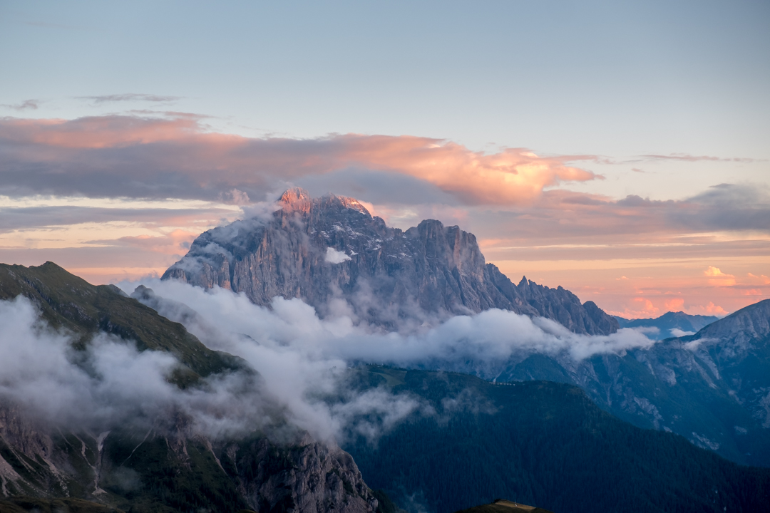
The weather was unbelievably hot as soon as we started our ascent to Rifugio Coldai. The view of the two major mountains, Mt Pelmo and Mt Civetta, was nothing but spectacular. I just could not stop admiring these giants. Despite the hot weather, we saw many day hikers on the trail. Local Italians from different age groups hiked up to Forcella Coldai to chill at the nearby (and perhaps famous lake) Lago Coldai, located at an elevation of 2143 m. It was remarkable to see so many of them enjoying nature — not to mention that they were all very fit and were able to hike super fast. When we made such remarks, they would tell us, “We’re Italians. We are used to hiking steep mountains!” They’re so lucky to have these mountains in their backyard for sure!
As we passed through Forcella Coldai (2,191 m), we finally caught a glimpse of the incredibly scenic Lago Coldai after hiking for about 4 hours. The lake rests underneath the high walls of Mt Civetta — an astonishing sight on its own. It was very tempting to follow the footsteps of the locals and chill by the lake, alas we still had a few more hours to hike. There was not enough time to stop. We followed the trail through a rocky terrain underneath Mt Civetta, occasionally traversing across a ravine. After a slight climb, we saw a glimpse of Rifugio Tissi, which is uniquely perched on top of a steep hill overlooking a valley and a small town of Alleghe and Mt Civetta. The idea of resting at this rifugio and calling it a day was pretty enticing, but we decided to keep going. We still had a few more hours until sunset and we still had the energy to keep going.


After passing Rifugio Tissi, we started descending towards a beautiful forest with a scenic view of Mt Civetta on one side. The forest was a perfect place to camp, but the problem was that there were no water sources nearby. Everything was so dry. We actually didn’t see any streams or water sources along the trail from the beginning of the hike, so rifugio was the only place where we refilled our water bottles. Some of these rifugios, especially those perched on top of a mountain above the tree line, require helicopters or cable-ways to bring water and supplies. This includes Rifugio Coldai and Tissi.

Thankfully, after descending for about 4 km, passing through green pastures where sheep and farm animals took their rest, we finally found clean streams. It was a perfect place to pitch our tent and it was not too far from Rifugio Vazzoler. Thankfully, we still got the southern view of Mt Civetta and we had one of the best sleeps in the tent after many days, finally! 🙂
Stage 7: Rifugio Vazzoler to Rifugio Bruto Carestiato
- Distance: 9.3 km (~ 4 – 5 hours)
- Elevation Gain / Loss: 627m / 507 m
- Where to snack/have lunch:
- Rifugio Bruto Carestiato
- Where to stay:
- Rifugio Bruto Carestiato
- Rifugio Passo Duran (+2.5 km from Rifugio Carestiato)
- Rifugio San Sebastiano (next to Rifugio Passo Duran)
We thought Day 7 would be a chill day since we tried to hike as much as possible before the sunset and camped the night before. But unfortunately, there was no “chill day” at Alta Via. Every single day of Alta Via had its own challenge. Today was yet another super hot day and the fact that most sections of this stage were overly exposed certainly did not help the situation at all. The whole stretch of path was also very rocky, traversing around the slopes of Mt Moiazza just above the tree-line, with uneven paths and a few more ravines that we had to cross.
By this time, my foot soles were very painful from stepping on those medium-size rocks. I could feel every painful step on those rocks. There were also no water sources, streams or whatsoever for the 9.3 km we hiked between Rifugio Vazzoler and the rifugio where we were going to stay for the night (Rifugio Carestiato). Not to mention that we ran out of water 4 km away from our destination and since I drank like a camel, it was pretty demotivating. I was really hoping I could find water sources near Forcella del Camp, but it was full of farm animals’ waste. With great determination, we finally arrived at around 3 pm, hoping for a proper lunch meal to be devoured. Unfortunately, we had to resort to eating another boring panini with cheese and tomatoes as lunchtime had sadly ended.
Despite all that, the views along this stage of Alta Via 1 were still spectacular. There was more greenery, with trees and forests covering most parts of the slopes of the mountains. Some stretches of the hike were devoid of people and I would have enjoyed these paths more than any other parts of Alta Via had it not been because of the hot weather.
Anyway, we stayed for a night at Rifugio Carestiato. We made a point to book our beds for this rifugio as well as the next one due to heavy thunderstorms that were forecasted in the next few days. We definitely did not want to take any chances and camping was not an option as we would probably be quite exposed to lightning.


Stage 8: Rifugio Bruto Carestiato to Rifugio Pramperet
- Distance: 13.8 km (~ 5-6 hours)
- Elevation Gain / Loss: 680 m / 657 m
- Where to snack/have lunch:
- Rifugio Passo Duran
- Where to stay:
- Rifugio Sommariva al Pramperet
- Rifugio Pian de Fontana (+5.8 km from Rifugio Pramperet)
Day 8 did not start well. In fact, I caught a really bad flu and thankfully I still had the energy to hike, albeit slowly. It was very difficult and the constant monsoon rain made everything worse. We were caught in the middle of thunderstorms as we reached the highest point on that day, near Forcella del Moschesin. The thunderstorms had just started. We were quite exposed with barely any trees around us so we had to hike as fast as we could since lightning could strike us anytime. It was a scary experience and I was so determined to leave this place as soon as possible, not giving any chance for those bloody bolts of lightning to strike me!


Thank God the rifugio was not too far from here so we managed to arrive safely. We were completely soaked — the ponchos did not help much in protecting our shoes and lower legs, of course. I barely took any pictures on that day as I was pretty weak. At Rifugio al Pramperet, we met some hikers who attempted the hike to the next rifugio, only to be turned back due to lightning that almost struck them as they were trying to climb the knife-edge ridge. It was pretty scary and there was no way we could tackle that section the next day as yet another thunderstorm was forecasted again. So we decided to stay at the same rifugio for the second night (Day 9) and it was a perfect decision as it allowed me to recuperate and regain my strength from the flu. It was also nice to finally relax and do nothing as we had been hiking non-stop for the past 8 days, with each day covering at least 13 km and elevation gain between 500-1k meters. We literally slept the whole day, only waking up for meals or tea. Best days ever!
Stage 9: Rifugio Pramperet to La Pissa
- Distance: 18.3 km (~ 8-9 hours)
- Elevation Gain / Loss: 805 m / 2,209 m
- Where to snack/have lunch:
- Rifugio Pian de Fontana
- Rifugio Bianchet
- Where to stay:
- Rifugio Bianchet
The last portion of Alta Via 1 was a long 18.3 km hike, with a total ascent of 805 meters and a knee-jerking descent of 2,209 meters. Since we stayed one more night in Rifugio Pramperet due to the bad weather on the previous day, we had to combine 3 stages into one to complete the whole hike. That means we had to start the hike before the sunrise — at 5 am (yep, hiking in the dark!). The best thing about hiking early is that we got to see the sun rises above the horizon. It’s been a while since I did a sunrise hike so it was pretty exciting! As expected, the view did not disappoint and it made me forget how hard and steep the start of the hike was.


Just before we reached the last highest altitude of this stage at 2,401 meters above sea level, we were faced with a knife-edge ridge, which we had to scramble up towards a cairn. It was a bit like the ridge in Bukit Tabur (in KL), but it was way less dangerous and shorter. Some of the hikers we met attempted to climb the ridge just when the thunderstorms were forming. They almost got struck by lightning so I was so thankful that we made a wise decision to stay put in the rifugio until the weather improved. After scrambling up the ridge safely, we hiked through a mountain pass (Forcella de Zita Sud) with breathtaking mountain views of the southern part of the Dolomites.


As we carefully started our super steep descent towards grassy slopes, we spotted a group of chamois on a nearby hill. Chamois is a type of mountain goat, which is smaller in size than the ibex and has shorter horns. They were quite majestic! The trail began to be gradual as soon as we entered the forests on our way towards a valley. Surprisingly, the view was still pretty scenic even as we arrived at the last rifugio in the Alta Via 1 trail, Rifugio Bianchet at 1,245 meters above sea level. The rifugio itself is surrounded by mountains!
After having our last meal on the trail, we rushed the remaining 6 km of our hike as we had to catch the last bus at 4.30 pm near the town of La Pissa. Thankfully, the descent was very easy and gradual through forests and rivers. We arrived at the bus stop 10 minutes before the bus arrived! What a relief! Alhamdulillah, we officially completed the 121 km hike of Alta Via 1! We had some doubts previously due to our heavy backpacks, but I was glad we managed to do it! It was time for a celebratory dinner 🙂

6 Responses
Hi there!
Looking to do a shorter section due to time constraints. Do you have a recommended 4 day route of Alta Via 1? Say, starting Sunday afternoon and ending thursday afternoon/evening?
TIA 🙂
Hi great post and some good info. Is there plenty of places to wild camp?
Hi! Did you do end up doing this? I’m trying to plan a 4 day trek for this summer
amazing !
Come on! Don’t camp in camping prohibited areas. If you’re a naturalist or outdoors person, as you must be to enjoy this hike, you can easily how hypocritical it is. It is about conservation of the natural areas, just don’t do it!
Hello do you know the coordinates for where you camped after lagazuoi?